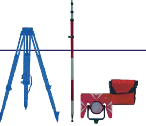
STANDARD PACKING LIST
| Main unit | 1x |
| Lens cover | 1x |
| Battery holder | 1x |
| Battery LB-01 | 2x |
| Tools Pouch | 1x |
| Plummet | 1x |
| SD Card | 1x |
| Manual | 1x |
| Warranty card | 1x |
| Charger LC-01 | 1x |
| Reflective sheet | 1x |
| Carry case | 1x |
| Belt | 2x |
| Mini USB cable | 1x |
- EN60825-1: 2007
- Good conditions: No haze, visibility about 40km. Overcast, no scintillation.
- Good conditions. With Koada gray card white side (90%) reflective. sheet size 60*60mm. 400m under good conditions with koada gray card grey side (18%).
- With Kodak gray card white side (90%) reflective. Reflector less range /accuracy may vary according to measuring objects, observation situations and environmental conditions.
- Range less than 200m. When 200m to 500m, 5+2ppm and measurement time maximum less than 10 second.
- Typical, under good conditions. Range less than 500m. It also depends on object surface. Maximum less than 10s.
OPTIONAL ACCESSORIES
- ATS-2 Wooden Tripod
- NLS-15 Prism Pole TK21T Prism Set
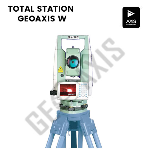
SPECIFICATIONS
| Distance Measurement | W9 | W7L | W7 | |
| EDM System | Laser Class 3R① | |||
| Wave legnth: 650 – 690 nm. 150MHz Frequency | Wave legnth: 650 – 690 nm. 150MHz Frequency | Wave legnth: 650 – 690 nm. 150MHz Frequency | ||
| Measurement Range | Single Prism | 3500m | 5000m | 5000m |
| Reflective Sheet | 1000m | 2000m | 1000m | |
| Reflectorless | 1000m | 2000m | 1000m | |
| Accuracy | Single Prism | (1+1ppm×D)mm | ±(2+2ppm×D)mm | |
| Reflective Sheet | ±(3+2ppm×D)mm | |||
| Reflectorless | ±(3+2ppm×D)mm⑤ | |||
| Measuring Time | Prism | Tracking<0.1s, Fine<0.3s | ||
| Sheet | <0.3s | |||
| Reflectorless | 0.3-3s⑥ | |||
| Atmospheric Correction | Manual Input, Auto Correction | |||
| Prism Constant | Manual Input | |||
| Dist. Unit | Freecale Sensor |
| Reading | |
| Measuring Time | Fine Mode<0.3s; Tracking Mode<0.1s |
| Atmospheric Correction | Auto Correction |
| Prism Constant | Manual Input |
| Angle Measurement | |
| Measurement Method | Absolute Encoding |
| Diameter of Absolute Encoding Disk | 79mm |
| Minimum Reading | 0.1ʼʼ or 1ʼʼ option |
| Accuracy | 1ʼʼ | 2ʼʼ | 2ʼʼ |
| Detection Method | Horizontal: 4 path, Vertical: 4 path |
| Telescope | |
| Image | Erect |
| Effective Aperture | 48mm |
| Magnification | 30 X |
| Field of View | 1°30’ |
| Minimum Focusing Distance | 1.2m |
| Automatic Compensator | |
| System | Dual-Axis Liquid-electric Sensor Compensation |
| Working Range | ±4’ |
| Accuracy | 1ʼʼ |
| Sensitivity of Vial | |
| Plate Vial | 30’’ /2mm |
| Circular Vial | 8’’ /2mm |
| Laser Plummet (Default) | |
| Accuracy | ±1.5mm (in 1.5m InsHt) |
| Wave Length | 630nm – 670nm |
| Laser Power | ≤0.4mW |
| Optical Plummet (Option) | |
| Image | Erect |
| Magnification | 3 X |
| Focusing Range | 0.5m – ∞ |
| Field of View | 5° |
| General | |
| Operate System | Windows CE 7.0 |
| Processor | Intel PXA310 624Mhz |
| Memory | 128MB DDR, 512MB NAND Flash |
| Display | 3.5inches LCD Touch Screen 640*480dpi |
| Communication | RS-232, Mini USB, USB OTG, SD card Bluetooth V2.0+EDR, 10m range |
| Battery | Rechargeable Lithium Battery |
| Voltage | 7.4V DC |
| Operation Time | 16 hours |
| Environment | -20°c ~±50°c |
| IP Standard | IP65 |
| Dimension and Weight | 196×192×360mm, 6.2kg |
WORLD’S FIRST- DUAL LASER EDM
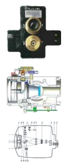
How does dual laser work
- Brand new dual laser EDM, it switches in & out light path by electronic laser circuit instead of motor control by mechanical parts.
- Combine with updated EDM processor CORTEX M4, dual laser EDM will largely decrease the interval of measurement with stronger return signal.
- Through improved noise reduction, weak signal processing is optimized (SNR increased 4 times).
- Less light refraction and crosstalk with optimized optical structure.
- Better alignment with coaxis mechanical improvement.
- Multiple methods for data transfer.
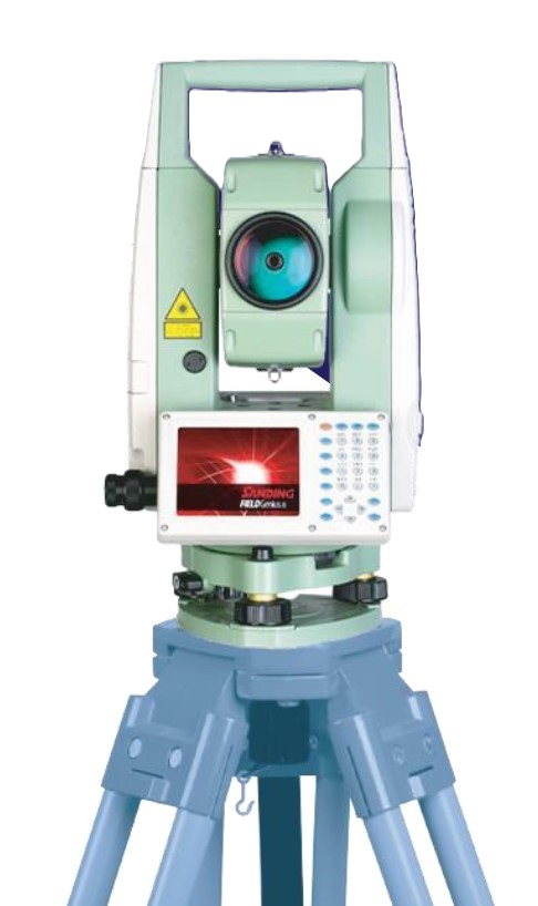
Long-Range EDM
Up to 2000m reflector less range with quick response in 0.3s. GEOAXIS W7 can easily handle the target in tough conditions, e.g. roof, wires. also enables GEOAXIS W7 to achieve accurate (2+2ppm) measurement in 5.0km with prism.
Smaller Laser Spot
At the distance: 5m, 35m and 50m, GEOAXIS W7’s laser spot has improved to an accurate size in 3mm, 12mm and 16mm. The smaller laser spot provides a precise guidance for target aiming.
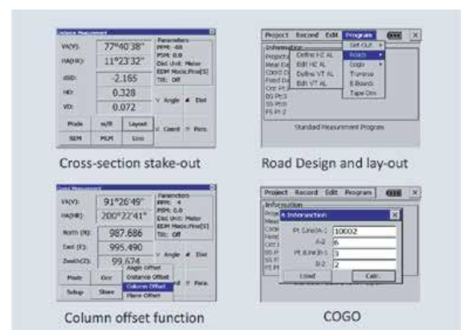
Easy-to-use Onboard System
GEOAXIS W7 series total station with fully-open Windows CE 7.0 operate system, featured South EGStar, MGStar, with unique applications.
-Reference Line
-Alignment Setout
-Cross-section Measurement and Stake Out – Slope Measurement
-Road Design and Stake Out
-COGO, etc.
GEOAXIS W7 offers the versatility of third-field software options to choose from, for example Microsurvey’s Field Genius, Carlson’s SurvCE or any other localized software. It allows you working in your best users experience and run your own developments under standard VGA display unit.
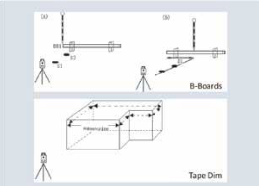
Unique Functions
B-Boards
When stake-out points, particularly for building plots, it is usually necessary to mark a point with an offset.
Tape Dimensions
Tape dim is a program which integrates surveying using a total station and a measuring tape when a quick survey of an object is required.
String Setout
Setting out of points by string (point code) allows the setting out of points on a line created in design software.
Onboard System
The large graphic display improves the efficiency to access menus and functions by fluent working-flow. GEOAXIS W7 afford a complete field-to-office solution to users, includes key features such as COGO Routines, Road Program, Coding, Resection, Stake- out, Reference Line, etc.
Windows CE 7.0 operating system also allows the user run the local software based on different market requirements.
Advanced Applications
GEOAXIS W7 series total station with the fully open Windows CE 7.0 operate system, featuring South EGStar, MGStar, Field Genius, SurvCE or any other localized software. It can meet different kinds of request or demands with a highest capability, easier the measurement than normal.
With advanced roading, surfacing, slope staking, smart points, GEOAXIS W7 is the best choice for your daily work.